DJI presenterar P4 Multispectral
Proffsdrönare för bönder
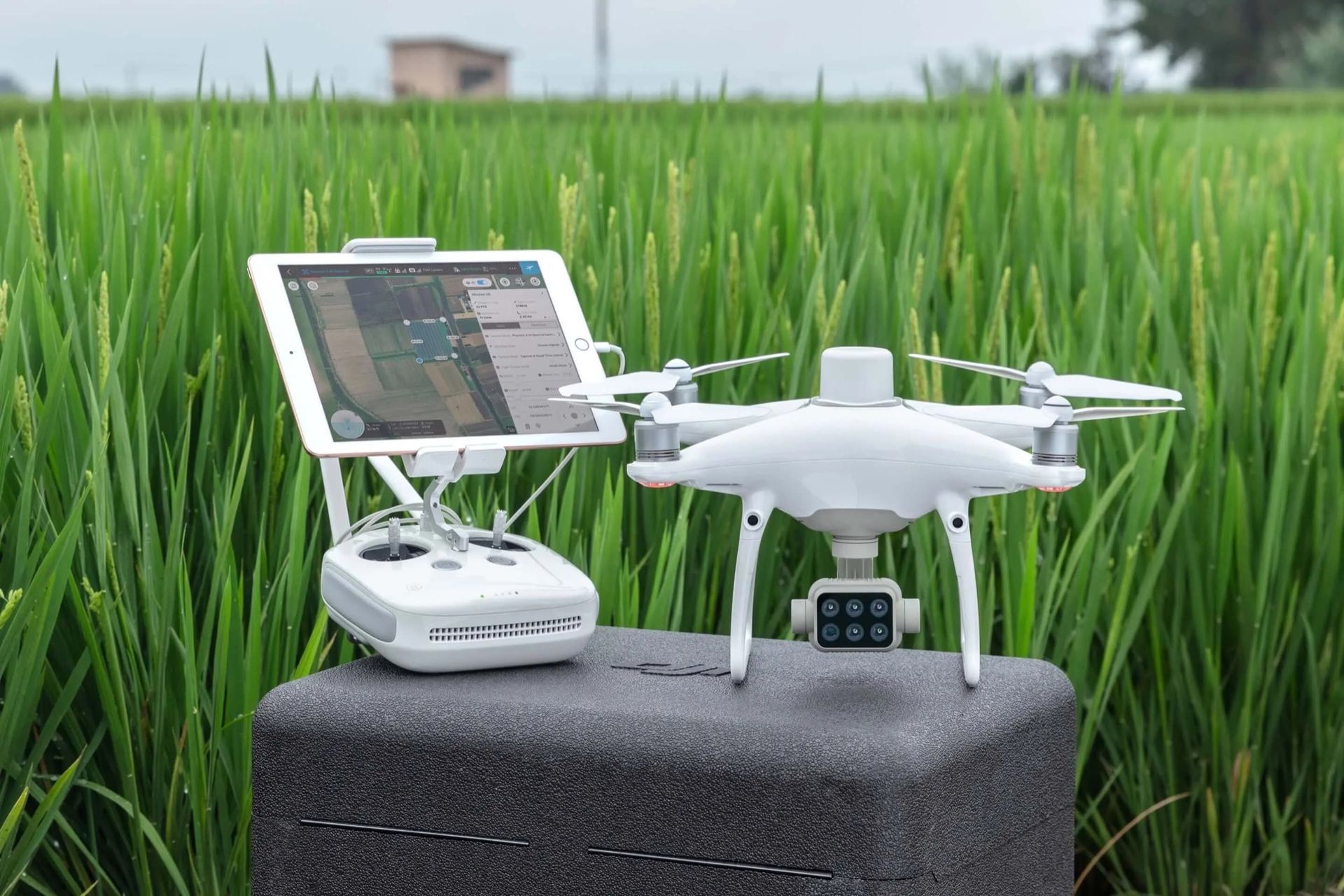
DJI har visat upp en ny proffdrönare som man kallar för P4 Multispectral som primärt är utvecklad för att användas inom jordbruksindustrin.Drönaren är försedd med en traditionell kamera samt en kamerauppsättning som bland annat har möjlighet att fånga upp infrarött ljus. P4 Multispectral är även försedd med en solljus-sensor som DJI säger ska kunna justera kamerorna beroende på hur solen lyser. Drönaren är utvecklad för att ge bönder och andra inom jordbruksindustrin en möjlighet att hålla koll på sina åkrar och grödor. Jan Gasparic, DJI:s partnerchef, säger att P4 Multispectral att det finns tre fördelar med att använda drönare för att samla in data från jordbruket: "You can scout fields in less time. You can see the unseen. And you can make decisions mid-season." Drönaren har en räckvidd på sju kilometer och en batteritid på 27 minuter. P4 Multispectral släpps i oktober och kommer då att kosta 6500 dollar.
dji.com
Pryl,
Drönare,
dji,
p4 multispectral
PRESSMEDDELANDE
DJI Introduces P4 Multispectral For Precision Agriculture and Land Management World’s First Integrated Multispectral Imaging Drone Built to Power Farming’s Next Generation
September 24, 2019 – DJI, the world’s leader in civilian drones and aerial imaging technology, is settinga new standard for easy-to-use agricultural drone applications with P4 Multispectral, the world’s first fully integrated multispectral imaging drone designed for precision agriculture and environmental management.
P4 Multispectral combines data from six separate sensors to measure the health of crops, from individual plants to entire fields, as well as weeds, insects and a variety of soil conditions. With the agriculture drone market expected to grow from $1.2 billion USD in 2019 to 4.8 billion by 2024[1], P4 Multispectral provides farmers and agronomists with a new tool to improve crop yields, cut costs and helps environmental professionals easily monitor vegetation on the land they manage.
“P4 Multispectral has the promise to transform the agriculture and land management industries by collecting precise plant-level data without having to send personnel into the field for manual surveys,” said Jan Gasparic, Director of Strategic Partnerships at DJI. “By combining multispectral imaging into a trusted, efficient and affordable tool, DJI is making this transformative technology more accessible to professionals around the world who are pioneering the adoption of drones in their industries.”
Precise Multispectral Imaging
P4 Multispectral features a gimbal-stabilized imaging system composed of one RGB camera and a multispectral camera array with five narrow band sensors – including red edge and near infrared – that are capable of capturing visible and invisible light. This data gives trained professionals unique insights into vegetation stress, soil composition as well as water salinity and contamination. An additional integrated spectral sunlight sensor maximizes the accuracy and consistency of data collection during missions flown at different times of day.
Seamless integration into the DJI Ground Station Pro flight planning app allows pilots to switch between real-time views of the drone’s RGB video camera and Normalized Difference Vegetation Index (NDVI) output for immediate insights while in the field. An integrated RTK positioning module and TimeSync system support real-time, accurate positioning data for each image, optimizing photogrammetric results and providing centimeter-level accurate measurements.
Industry Workflow Compatibility
P4 Multispectral is compatible with standard industry workflows including flight programming, mapping, and analytics software from DJI and other leading providers. Using the DJI GS Pro application, users can create automated and repeatable missions including flight planning, mission execution, and flight data management. Data collected can be easily imported into DJI Terra or a suite of third-party software including Pix4D Mapper and DroneDeploy, for analysis and to generate additional vegetation index maps. In addition, P4 Multispectral users can enhance the accuracy of RTK positioning without an internet connection by using DJI’s D-RTK 2 High-Precision GNSS Mobile Station, whichsupports all major global satellite navigation systems, or using a third-party network RTK via an iPad with an internet connection.
Powerful Performance
Built on the iconic Phantom airframe, P4 Multispectral leverages DJI’s powerful OcuSync transmission system for a smooth flight experience with less signal interference, enhanced video transmission, and a 7km maximum transmission range.[2]Each of its 2-megapixel cameras feature a global shutter for precise imaging during flight with a maximum 27 minutes of flight time per battery.
Availability
DJI P4 Multispectral will be available in October through authorized DJI Enterprise dealers worldwide. The P4 Multispectral costs $6,499 USD and comes with a 1-year free license to DJI Terra (Basic) Windows software and a 1-year free license to DJI GS Pro (Team-Professional) iPad app. Customers can also purchase the P4 Multispectral with the D-RTK 2 Mobile Base Station for a total of $9,100 USD. All purchases of a P4 Multispectral in the United States, Canada, China, Australia, Japan, United Kingdom and the European Union will enjoy a 1-year Enterprise Shield Basic coverage on their new drone, at no additional cost.
To find a local Enterprise dealer, visit www.dji.com/where-to-buy.
39.6°
0Wille Wilhelmsson
mån. 30 sep 2019, 08:50
+
Per månad
39 kr
Betala löpande per månad. Ingen bindningstid.
Starta prenumeration
Per år
299 kr
Enklast och billigast, bara 25 kronor i månaden. Betala löpande per år. Ingen bindningstid.
Prova 14 dagar gratis innan du bestämmer dig.
Starta gratis provperiod
Engångsköp
349 kr
Slipp återkommande betalningar, betala ett år i taget. Betala med kort eller Swish.
Köp utan prenumeration